Advertisement
Forecast: Possibly Historic Blizzard To Hit Boston Monday Into Tuesday
Editor's Note (January 2016): Since a lot of you are reading this post in January 2016, we want to be very clear: This forecast is from January 2015. Our forecast from Jan. 19, 2016, can be read here. Thanks!
After Saturday brought Boston the season's most significant snowstorm, it now seems that storm was a warm-up routine for the one coming our way Monday night.
A major, perhaps historic storm is going to begin across southern New England Monday evening and continue through Tuesday evening. This storm will bring strong winds, heavy amounts of snow and coastal flooding. Many regions throughout the state may also experience power outages.
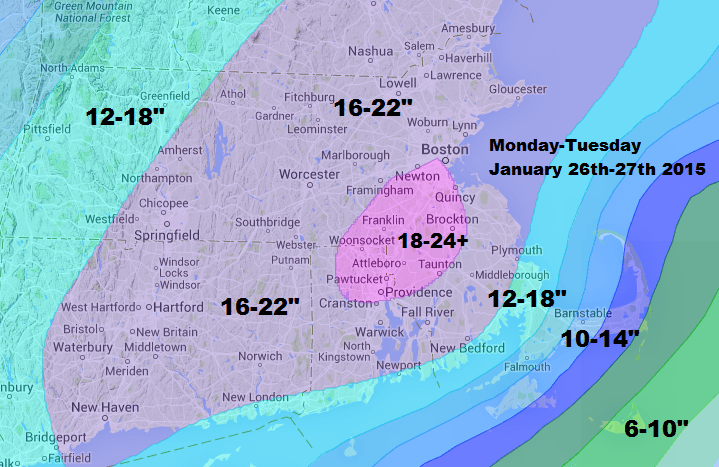
A blizzard watch as been issued for eastern Massachusetts. This means winds have the potential to exceed 35 miles per hour for three hours or more, and that this combined with the snow will lower visibility to a quarter mile or less. While a blizzard doesn’t necessarily mean large amounts of snow, this particular blizzard will feature a lot of it.
The storm's cause is rooted in a low pressure system currently centered in the Ohio Valley that will move east to the Atlantic coastline Monday and then intensify into a major nor’easter. This storm has the potential to be one of the strongest storms in several years.
Power will likely be interrupted in many locations as the strong winds damage trees and electrical lines. The snow will be heavy and wet over Cape Cod and the Islands, but a lighter and fluffier snow is going to fall over inland areas.
Coastal flooding is a concern on Tuesday. There are two high tides which will bring possible flooding conditions. The first high tide will occur at 3 a.m., and the second will happen 12 hours later at around 3 p.m. Check your local tide chart for exact times.
A high wind watch is posted for Cape Cod and the Islands, as this is where the winds will be the strongest and could cause the most severe damages.
Snow will break out across the area after the evening commute Monday. There could be some light snow during the commute, but the bulk of the storm will occur well after most people are home.
The storm continues through the overnight Monday and into Tuesday, ending Tuesday evening before midnight. Sunshine will return for Wednesday.
Sunday: Mostly sunny and brisk with a high near 35.
Sunday night: Mostly clear and cold. Lows 9-15.
Monday: Early sun, then thickening clouds. Some light snow late in the day.
Monday night: Snow and wind. The snow becomes heavy at times. Lows in the teens and 20s.
Tuesday: Snow with areas of blowing snow. Very windy and cold. Highs 18-28. Temperatures in the 30s for the Cape Cod area.
Tuesday night: Snow ending by midnight. Lows in the teens.
Wednesday: Partly sunny, with a high in the mid 20s.
Thursday: Mostly sunny, with a high near 30.
You can follow David’s weather updates on Twitter at @growingwisdom.
